For Old Codgers Who Fantasize About Gold and Recycle Treasure
John has prospected for gold in Arizona 10 years. His experience taught him to deal with the terrain, heat, and gold fever. He makes tools.

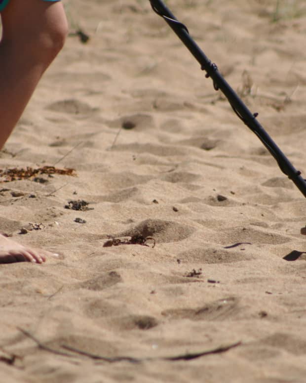
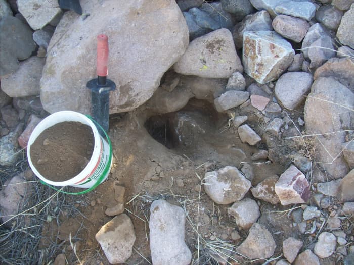
First feeder wash with boulders that looked promising
John Wilsdon
Surveying the Area
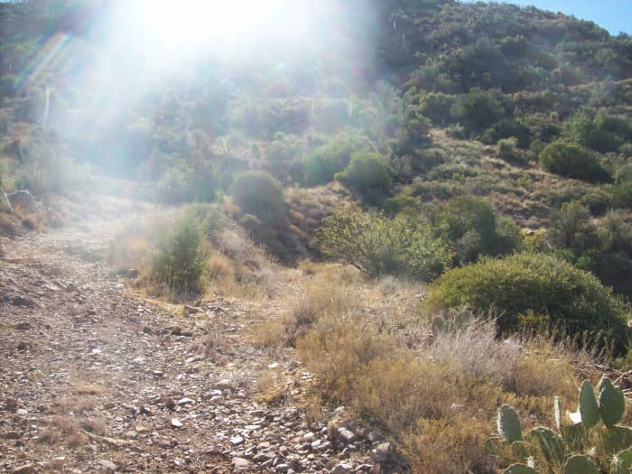
One day I found a trail off the side of a road that wound around the base of a local copper mining area. Why not take a hike and see what was up there? And, there was evidence of lots of porphyries, and I mean a lot!
From my truck, I could see boulders piled high in the wash below. This meant that powerful floods had pushed rocks from the distant mountains over a long distance. Upon hiking to the bottom of the boulder wall, I chose a couple of spots to sample dirt for placer gold. I have a couple of small buckets I use for sampling. The boulders are to the side and higher up than the main wash. Water will only reach there when the flood waters are high. That area was actually a bottom bank. Prospectors sometimes refer to this labor as bank work.
Age Is a State of Mind
For those of us who are a bit long in the tooth, prospecting for gold can provide an opportunity for profit, as well as a chance to savor the outdoors. In addition to hiking to discover old mines, I also search for gold flakes in washes and use some reasoning in choosing my digging sites.
The large rocks in the wash provide a barricade that creates eddies where the water of floods slows. Heavy gold flakes would sink to the bottom if any placer was in the runoff. There was also a lot of quartz and porphyry around.
The photographs I get along the way are wonderful, especially if the end of my hike is at an abandoned mine. And along the way, I love to gather those recyclables.
I like to use a Minelab trowel because it won't bend and it has a serrated side to saw through roots. Ad old mud bucket is the right size for sampling. If you dig, fill the holes.
John Wilsdon
Taking a Sample
收集一桶样品材料后,我started the journey up the suspect trail. Immediately it became evident that this had been a well-traveled trail. On either side of the trail, there were mainly beer cans and plastic drink bottles, but also lots of other refuse. I will impart an old codger's gained wisdom about recycling while hiking to discover old mines. These tips will help those who already know they like to recycle and are interested in gold and profit.

Collecting recycling along the way can be profitable.
John Wilsdon
Pocket Change
During this adventure, searching what I suspected was a mine trail, I collected three pounds of aluminum and 1 pound of assorted plastic bottles, which yielded $3.00. All I had to do was bend over and pick them up. Mining camps are notoriously grubby places.
Some small mining operations leave dump piles near the mine; most larger operators currently work hard to minimize the environmental impact. Perhaps even more notorious offenders are some hikers, campers, homeless, and those with off-road vehicles who congregate at such sites while exploring.
Adventures
In a previous article, I had quite an adventure hiking to find a prospective abandoned mine. Since I live in Eastern Arizona, I live near the Superstition Mountains and a number of other chains in the region. Once you gaze at the mountains in Pinal County, you can't help but be curious about what is in them.
The occasional reddish tones of many of the mountains make you suspect there might be something precious around. The prevalence of quartz and volcanic quartz rock is another tantalizer. The area has been mined for over 250 years. Though copper is king, wherever there is copper and silver, there is probably gold. How much gold is another thing altogether?
When I say I get enthused by reddish tones on the sides of mountains and hills, there is a reason behind the enthusiasm. Iron melts at 1528 degrees, while quartz melts at 1338 degrees. Gold melts at 1064 degrees. Why is this important?
Well, imagine living at the time of the tumult that occurred when the earth was being formed. There were volcanoes everywhere. That heat and gas pressure pushed all kinds of minerals from the bowels of the earth up to the surface. Five hundred degrees one way or the other, and you can get elements boiling up together. Iron, quartz, and gold are frequently found together, having been pushed up as iron was blown to the surface.
Read More From Toughnickel


And, of course, when the iron is exposed to oxygen, it forms iron oxide or rust, and rust has a reddish tinge. When you see a volcanic rock with quartz streaks in it, pay attention. The geologist's term for this is porphyry.
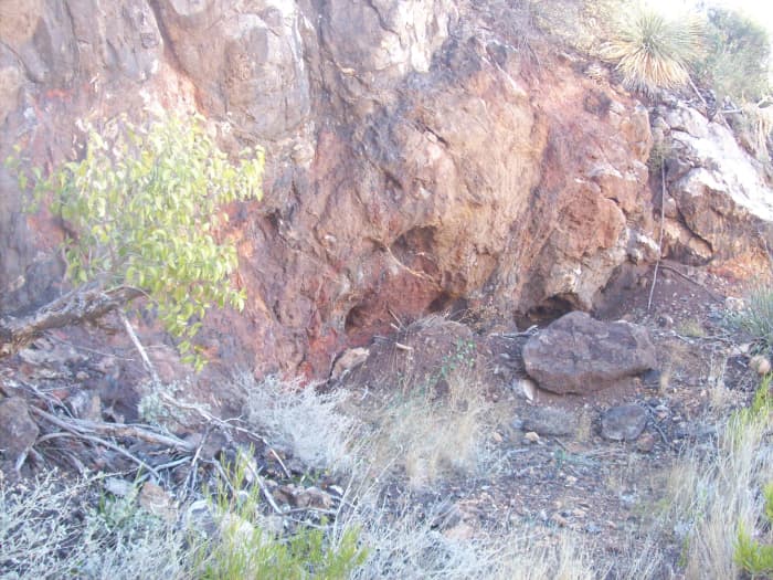
A large rock face, red tones, quartz streaks and round holes—the hardness of the rock was consistent across the face—these looked like chipped out holes. A clearing was in front.
John Wilsdon
A History of Past Mining
减弱侧面arou主干道的伤口nd the base of a local copper mining area. Why not take a hike and see what was up there? And, there was evidence of lots of porphyries, and I mean a lot!
On either side of the trail, there were mainly beer cans and plastic drink bottles, but also lots of other refuse.
As you walk up the trail, there may be lots of recyclables—accumulate them and pitch them in the middle of the trail. You can collect the recycling on the way back from your destination or whenever you tire out. This alleviates the problem of carrying the recycling up the trail, usually at an incline. With any luck, you will find a mine, take samples, and get a lot of photos. Remember, hiking down a trail is most often easier than walking up, and carrying a load seems less fatiguing.
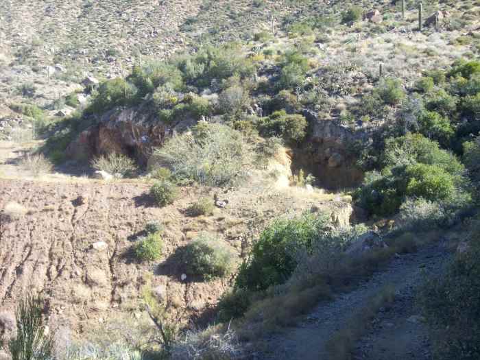
And then, off to the right, I see what may be tailing drifts. The drifts down the side of the mountain are porphyry, and it might be what was blown out of the mine and worthless to the sourdoughs. As you can see in the photos, the drifts extend down quite a way, and I will have to get up to them. The trail winds around to the south and up the rise to the area in question. Perhaps I can go down the gorge and up the other side for a shorter trip, but that remains to be seen.
If the incline is too steep and there is a lot of gravel, I may not be able to scale it. But all of this is promising. I also see another drift. At the top of it, there is an area of brown dirt that seems to have been pushed out and built up. Could it be the front of a mine where the dirt of the mountain was used to build a level spot? That could be another good sign of a mine.

Cleared area with a dirt build up. A road leads up to it and beyond. This looks promising.
John Wilsdon
Fork in the trail—right trail leads to dirt build up on side of hill—left goes up a mountain
John Wilsdon
Leave a Trail for Next Time
I choose the left trail, even though the right leads to the previously viewed abandoned mine possibility. A longer hike up the other hill seems right for the day. I want to look out from the top to see what's on the other side and to my back, what my community looks like from there.
As the walk progresses, I see more and more quartz on the trail. This is a good sign. But what I am looking for is any indication that someone claimed an area up ahead or even posts for a gate, chain, or cable barrier. That doesn't happen unless somebody is serious about mining or something else for profit. Lo and behold, posts become visible as I meander up the road.

屏障的帖子
John Wilsdon
Saguaro Sentinels Watching West
Of course, along the way, there are a lot of unusual things to see. The area is full of beautiful saguaros. When damaged, the saguaro can grow in strange ways. One saguaro had a blown-out part that was scorched; I suspect it was hit by lightning. Another was damaged and grew two arms on either side that produced a perfect U. Handsome stands of saguaros abound.
By the way, saguaros populate thickest on the western and southern sides of the hills in Arizona because the prevailing winds blow west to east or south to north in summer, with rain falling mostly there.

A delightful stand of saguaros above a wall of boulders thrown down the mountain in violent floods.
John Wilsdon

Unusual shapes in the high desert are common.
John Wilsdon

From the lightening scorch mark, the limb grows out to the right.
John Wilsdon
I see an area up ahead that looks favorable. It certainly looks like a small mining operation. The tailings have been pushed over the side and have built up the area to the front of a possible mine access. The red and white tones and a few black streaks are reassuring. Something resembling shadows or hollows can be seen.
Quite a site after traveling a few miles uphill.
John Wilsdon
This large rock face, in my opinion, has been worked. There are a number of suspicious carved areas, but one, in particular, is either a mine or a cave. I think it is a mine, and I believe that there was an attempt to block it. You can see from the photo a pile of earth in front that appears to have been pushed. There is also evidence of stones and moisture inside.
I pushed my head into the hole and, with a flashlight, was not able to see the end of the tunnel. From the opening, there was a sharp turn to the left that went down at about a 45-degree angle. That was enough delving into an unknown opening. It is possible that what I was looking at was the top of the mine entrance. Who knows? What is really alluring is the white streak down the back of the rock.
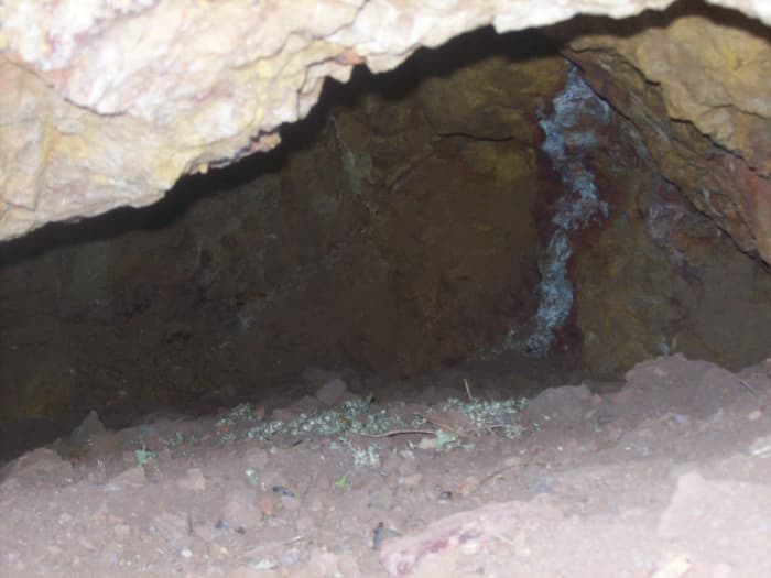
A cave or a mine entryway. Notice the vertical white streak. The tunnel extends to the left as far as you can see.
John Wilsdon

Scrub pine—the first I saw and the end of the trail not far beyond.
John Wilsdon
A Peak View
在土壤和岩石的一些样品,我无法忍受inued up the trail to the pinnacle of the mountain. On the way, I was making my way to the scrub pine zone. There were pine cones all over the place. And at the top, the road ended. I emerged to view the other side of the mountain. A bivouac area with fire circle and ashes were all to be seen. Evidently, it was a viewing point and a camp for hikers.
I arrived back at my truck about four hours later. The trail never becomes uncertain. This is evidence of traffic up and down on occasion, probably from jeeps and ATVs. Beer cans were evident all the way up, but the higher one goes, the less frequent the cans appear. It was a fun jaunt.
If you want to do something like this, wear long pants and use boots, not tennis shoes. The rocks on the road are sometimes sharp. Bring water and make sure your cell phone is fully charged. I know this was not a beginner's hike, but beyond that, I don't know how to appraise it. Talk to an experienced hiker or search and rescue for advice on taking an outing in the Arizona hills.
This hike took place near Government Mountain at 4196 feet.

Water can carve grooves in the rock over the years, and the colors can surprise.
John Wilsdon
Conclusion
The west was pretty thoroughly prospected by 19th-century miners. Chinese and European immigrants scoured the land. Then in the 1930s, experienced Appalachian miners worked the area due to the Great Depression. Anybody who knows anything will tell you not to quit your day job for gold prospecting unless you have good knowledge and lots of money.
But hunting for placer can be satisfying if you enjoy nature and a hunt and don't expect to ever get rich. When you factor in the excitement of finding any gold, taking in blue skies, photographing the natural wonders—including animals—reclaiming littered metals, and exercising, hiking for lost mines can be quite the reward.
This content is accurate and true to the best of the author’s knowledge and is not meant to substitute for formal and individualized advice from a qualified professional.
© 2018 John R Wilsdon
Comments
John R Wilsdon (author)from Superior, Arizona USA on January 29, 2018:
Thanks for taking the time to respond. It's fun to have a little adventure and be able to share it. Another benefit-
Readmikenowon January 29, 2018:
I really enjoyed reading this. Sounds like it was a great adventure no matter what the outcome. Good article.
John R Wilsdon (author)from Superior, Arizona USA on January 28, 2018:
Funny. I have that same dream. It never goes away. If I found one, I wonder if the dream would continue? I think so. Australia has a history of rich gold. Thanks for the comment.
K S Lanefrom Melbourne, Australia on January 28, 2018:
Great Hub. I live in an area known for gold and I often fantasise about tripping over a massive nugget on an evening walk.